Product Description
Product parameters:
| Infrared imaging | detector | Uncooled focal plane alum oxide |
| resolution | 640×512 | |
| Pixel size | 12 μm | |
| Operating band | 8μm ~ 14μm | |
| NETD | ≤40 mK | |
| Infrared lens | 50mm F1.0 | |
| Field of view | 8.8°×7° | |
| Lens control | Electric focusing/autofocus | |
| Identification distance | ≥ 2.5km for medium-sized vehicles; ≥ 1 km for pedestrians | |
| Optical parameters | Visible light magnification | 5x |
| Field of view | 40°×32° | |
| Visible light imaging | detector | CMOS |
| resolution | 3264*2448 | |
| Pixel size | 1/2.8 | |
| lens | WFOV 40°×32°, NFOV 0.35°×0.28° | |
| Identification distance | ≥ 9.5km for medium-sized vehicles; ≥ 4km for pedestrians | |
| Laser ranging | wavelength | 1535nm |
| Measurement range | 30m~3000m (medium-sized vehicle) | |
| accuracy | ±2m | |
| accuracy | 98% | |
| Positioning and Orientation | model | BeiDou/GPS/GLONASS |
| Positioning accuracy | 5m (CEP), 10m (PE) | |
| Target positioning accuracy | ≤20m@1Km | |
| Positioning angle accuracy | 0.1° (RMS) Pitch angle / 0.2° (RMS) Azimuth angle | |
| Intelligent magnetic declination automatic correction | Automatically identifies local magnetic declination (at a specified location), eliminating the need for manual correction. | |
| Laser pointer | Invisible | 850nm, 30mW |
| Meteorological parameters | temperature | -40℃ ~ 60℃ |
| humidity | 0%RH ~ 100%RH | |
| wind speed | -25m/s to +25m/s | |
| accuracy | ±1m/s | |
| air pressure | 200hPa ~ 1100hPa | |
| Measurement accuracy | ±10hPa | |
| Ballistic calculation | Ballistic storage quantity | 10 groups, supports user input |
| accuracy | Wind direction deviation 0.5 mil, firing angle deviation 0.5 mil | |
| Multi-missile ballistic calculation | It can measure meteorological parameters such as temperature, humidity, and atmospheric pressure. | |
| Includes 267 ballistic parameters (customizable). | ||
| Wind direction deviation can be adjusted | ||
| power supply | Battery | ICR18650 x4 sections |
| Working hours | ≥5.5 hours (room temperature) | |
| show | binoculars | OLED, 1920×1080 |
| diopter | -5 ~ +5 | |
| storage | capacity | 128GB, video storage ≥ 4 hours, BMP images ≥ 10,000 |
| interface | aviation plug | Standard USB, RS232, PAL, DC12V |
| WIFI | Control and image transmission | |
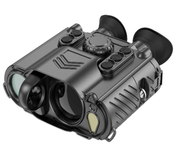
| physical parameters | weight | ≤ 1.75 Kg (including batteries) |
| Dimensions (Length × Width × Height) | 210mm×178mm×75mm | |
| Package level | IP67 | |
| Operating temperature | -40°C ~ +60°C | |
Product Introduction:
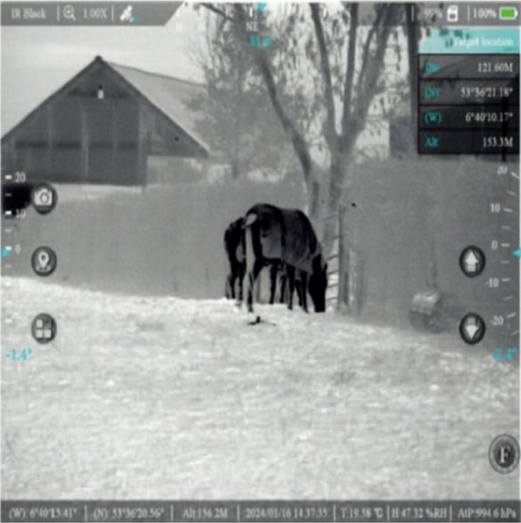
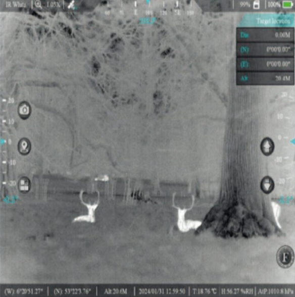
The sniper aiming assistance system integrates infrared imaging, visible light imaging, laser rangefinding, positioning and orientation, and meteorological measurement, enabling target detection and location day and night. Its built-in ballistic algorithm allows for all-weather aiming, real-time collection of meteorological data related to shooting, and ballistic calculations to assist in firing. This handheld infrared detection device, with multiple functions and applications, is a system composed of various advanced sensors, signal processing circuits, and optical components, allowing for all-weather observation and detection of targets, day and night. Equipped with a long-wavelength uncooled infrared detector, it provides high-quality, high-resolution infrared images. It can search for and detect targets in complete darkness, fog, haze, and smoke. A high-performance ultra-low-light/visible light detector can be used independently or in conjunction with an infrared detector to help users find and compare concealed targets. It also integrates eye-safe laser ranging, a GPS/GNSS joint positioning system, and a digital electronic compass, helping users locate observation positions and target orientations, enabling rapid target detection and handling. Simultaneously, it employs advanced image compression algorithms to record real-time images, facilitating simultaneous sampling and evidence collection. With professional functions and user-friendly operation, it meets the needs of various users, significantly reducing the number and weight of reconnaissance equipment carried, improving the ability to process various information data in a timely manner, and shortening reaction time. The system boasts excellent waterproof and dustproof performance, a compact structure, light weight, durability, shock resistance, and interference resistance, allowing for use in all weather conditions.
Features:
5x fusion optical zoom;
Fusion Focus (Picture-in-Picture);
It has infrared thermal imaging, visible light, laser ranging, and indication functions;
It features intelligent magnetic declination automatic correction, ensuring accurate target positioning;
Equipped with multiple built-in weather sensors;
Equipped with WIFI control and image transmission;
It has multiple ballistic information options (optional).
It features manual or automatic brightness and contrast adjustment.
It features wide dynamic range, 3D noise reduction, and automatic shutter.
It has photo and video recording functions;
It features 1x, 2x, 4x, and 8x electronic amplification.
It is equipped with an electronic compass, which can overlay the directional information output by the electronic compass on the display screen;
Equipped with BDII positioning function, it can overlay coordinates on the display screen;
Capable of fog-penetrating imaging;
Additional Information
It integrates an infrared thermal imaging module, a visible light module, a laser ranging module, a satellite positioning module, a meteorological sensor module (including wind speed, wind direction, temperature, humidity, air pressure, etc.), image processing, recording, storage, and transmission trajectory calculation.